Sunday 20 March 2011

Section 1 : Investigates the long term impacts of volcanoes.

Main question in this section:

1. Why is the impact of the Mt.Bromo 2011 eruption still being felt today?


The First picture on the top seems to be a beautiful scenery of Mt Bromo, a tourist attraction in Indonesia. 

In reality, during the massive eruption of Mt.Bromo on 21 January 2011, the entire area is covered with thick dark ash which covered the other mountains surrounding it. Look how massive the eruption is and how much of it is blown away. Even the nearby people living in the villages could feel the impact.

Months after the eruption, the impact can still be felt. The lives of people, the animals, the trees, climate and plants.


2. How is this region still being affected?

The region is still heavily affected by the Mt. Bromo eruption from the 806 hectares of protected forests in the area of Bromo Tengger Semeru National Park heavily damaged in just a matter of days. This thus caused the people living near the volcanoes, even until now to have difficulties in finding food from the forests such as wild animals as most of them have been killed in a massive eruption. Till today, the transportation infrastructure from Cemoro Lawang Village until Ngadisari Village have not yet been recovered. This thus cause people from both Cemoro and Ngadisari Village huge inconvenience. The ash also damaged agricultural crops in the nearby village. These crops are very important to them because it is a source of living for them and takes 4-6 months for a complete field to grow. From the eruption date till today, it has only passed 2 months hence the crops would not have fully grown causing these people to rely on other food sources. The river valleys where villagers collect water has also been contaminated although the condition of the water are now improving, it is still difficult to get pure clean water.


3. Why is this area finding it more difficult than most to get back onto it's feet?

After the eruption, lots of people would also be left homelessHouses, buildings, roads and fields would also be covered in ashes.There would be a decline of the country's population due to the whooping numbers of casualties from the hot lava and or the suffocating volcanic ash emmited, which is cause by inadequate information on the eruptions. Since there are lesser people working and staying near Mount Bromo, the area would find it more difficult than most to get back onto it's feet.


4. Consider the characteristics of the country. How does the development play a part?

Apart from fertile land suitable for agriculture, Indonesia is rich in a range of natural resources, such as tin, bauxite, nickel, copper, gold, and silver. After eruptions of the volcano, the land will become fertile which farmers can use to grow crops,and then sell them, helping the economy with supplies of food.There's also a slight chance that the volcano might have jewels,which will cause mining and and a boost to the ecomomy. The eruption can also cause land slides, which might end up destroying part of a town,which will cost the government a huge sum of money. Tourist would also not visit the places near volcanoes as the volcano may still be active and most of the towns near the volcano would be destroyed so there would not be much to see. Since there would be less tourist visiting the country, the economy would be worst.


Section 2 : Ways that volcanic eruptions can be predicted.

Main question to this section:

1. To what extend can volcanoes be successfully predicted?

Tiltmeter


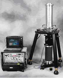
Rising magma within a volcano often causes ground deformation.  This instrument measures ground deformation measured by tiltmeters. Tilting is for instance measured when rising magma makes a bulge. 

Below are some of the other methods:

Hazard assessment maps


On the hazard assessment maps the areas of greatest danger and highest risk around a volcano are defined.  It is very important the danger zones have been pointed out very precisely and correctly so the people who are living in those areas or danger zones can be evacuated.


Seismograph


The seismograph uses a pendulum to record movement of the ground below it. The squiggly lines recorded on paper by a seismograph are called a seismogram.


Gravimeter


Since magma gives off electric currents, electric meters are used tospot rising magma levels by measuring its electric current. Gravimeters can also detect flowing magma.


Landsat satellite 


Scientists also take temperatures and gauge gas by using a Landsat satellite. The satellite uses infared sensors to detect temperatures and changes in volcanoes.

GPS (Global Positioning System)


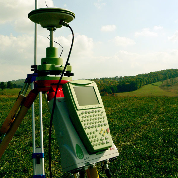
This is an example of a GPS.

GPS(Global Positioning System) is a method to determine position of locations on Earth. It uses satellites that broadcast a signal and receivers that pick up and record the signal. GPS uses the relationship between velocity, distance, and time (with GPS, the velocity is the speed of light. Knowing the velocity and time (and the position of the satellite) allows the distance to be calculated. As magma moves up into a volcano the volcano swells and distances between points on the volcano increases) and the elevation at specific points increases. Such a change is a common occurrence prior to an eruption.

In conclusion, volcanologists use these instruments to successfully predict eruptions which saves many lives. Scientists are trying to develop new ways to predict future eruptions.

2. How accurate are these techniques?
These  techniques are definitely very accurate but sometimes, a volcanic eruption are just unpredictable. Hence, these equipments or techniques help volcanologists study the changes of an active volcano and  predict when these volcanic eruption would occur so that people would not feel the imminent danger

3. Why is it generally easier to predict volcanic eruptions than earthquake?
Volcanic eruptions are easier to predict than earthquakes, as minor earthquakes are often the first 'sign' of a following volcanic eruption. The example of Mount St. Helens underlines this, as first signals of a coming volcanic eruption could be noticed already three months before the actual eruption. These signals can be either minor earthquakes or even gas production in a volcano shows that it is 'active.'

Earthquakes are harder to predict as they occur suddenly without any warning or with short notice. However both earthquakes and volcanoes can be monitored and observed by seismographs, tilt meters, lasers, GPS and observation. Furthermore some animals like catfishes can be used to predict them as they are very sensitive. It is also possible to create hazard maps as prediction for volcanic eruptions. These are based on previous eruptions and close observations

Section 3 : Why people continue to live in areas where volcanoes are found.

Main question for this section:
1. Why do people continue to live near volcanoes?

They chose to live close to volcanoes because they felt that the advantages outweighed the disadvantages.

Minerals


Magma rising from deep inside the earth contains a range of minerals. Most of the metallic minerals mined around the world, particularly copper, gold, silver, lead and zinc are associated with rocks found deep below extinct volcanoes. This makes the areas ideal for both large scale commercial mining and smaller scale local activities by individuals and small groups of locals. Active and dormant volcanoes have the same mineralisation, so like extinct volcanoes, they are rich sources of minerals.

Geothermal Energy


The heat from underground steam is used to drive turbines and produce electricity, or to heat water supplies that are then used to provide household heating and hot water. Where steam doesn't naturally occur it is possible to drill several deep holes into very hot rocks, pump cool water down one hole and extract steam from another hole close by.

Fertile Soils


Volcanic rocks are rich in minerals, but when the rocks are fresh the minerals are not available to plants. The rocks need thousands of years to become weathered and broken down before they form rich soils. When they do become soils though, they form some of the richest ones on the planet. Mount Vesuvius, has such rich soils thanks to two large eruptions 35,000 and 12000 years ago. Both eruptions produced very thick deposits of ash and broken rocks which have weathered to rich soils.

Tourism


Volcanoes attract millions of visitors every year, for different reasons. As an example of the wilder side of nature, there are few things that can beat seeing an erupting volcano blowing red hot ash and rock thousands of feet into the air. Even the less active ones that are just puffing out steam and smoke are impressive sights and attract tourists from around the world.
Tourism creates jobs and generate income.
1. Why are there so many people living near volcanoes. Is it a stupidity or practically?
2. Are the reasons different in DCs [Developed country] compared to LDC's [less developed country]?

It is both a stupidity and practically. This is because some people feel it is practical as they think the advantages living near the volcanoes outweighed the disadvantages hence they live there. Truly, there are many advantages living near volcanoes eg. fertile soils after eruption, minerals can be collected and sold at a high price, geothermal energy which gives them electricity and etc.

While others feel it is stupid because life is more important than money. What if a volcano erupt? Everyone would die including your family hence it can also be stupid to some people. But majority of the farmers and villagers have no choice as it is their living. If they do not live near the volcanoes they would have no where else to live and no money for a living.

The reasons are different because DCs have government support which gives them a choice whereas LDCs do not have such privileges.


Section 4 : What more can be done to reduce the negative impacts of a volcanic eruption.


Main question for this section:

What more can be done to reduce the negative effects of volcanic eruptions?

In recent years, with the eruptions of Mount St. Helens and Mount Pinatubo many advances have been made in the study of volcanoes particularily in eruption prediction. The problem with volcanoes is that, though there may be similarities between volcanoes, every volcano behaves differently and has its own set of hazards. That is why it's important for scientists to study and monitor volcanoes. Many active volcanoes near populated areas have not been sufficiently studied to assess risk.

When scientists study volcanoes, they map past volcanic deposits and use satellites to look at volcanic features, ash clouds, and gas emissions. They also monitor seismic activity, ground deformation, and geomagnetic, gravimetric, and geoelectrical and thermalchanges at a volcano.
They study and monitor volcanic gases and monitor the temperature, flow rate, sediment transport, and water level of streams and lakes near the volcano.

By studying volcanic deposits, scientists can produce hazard maps. These maps indicate the types of hazards that can be expected in a given area the next time a volcano erupts. Dating of these volcanic deposits helps determine how often an eruption may occur and the probability of an eruption each year.

Monitoring of a volcano over long periods of time will indicate changes in the volcano before it erupts. These changes can help in predicting when an eruption may occur.

Limiting hazardous effect of volcanic eruptions is restricted to evacuation and planned development based on the predictions made. Prediction is less possible for areas without much data or equipments for measuring the fault accumulated in strains.

Prediction of volcano eruptions has been more successful because the volcanoes would produce more signs of potential eruption before the actual event.

Volcanologist are able to make predictions through the close study of the volcanic gases emitted, the volcanic materials that are released by the vent, the tilt of the volcano, the acidity of the springs in the volcano, and the seismic activities. Prediction of the eruption of Mt. Pinatubo in the 1991 has been lauded as one of the most successful attempts at fore-telling the event.

Besides evacuating the residents around the volcano and modeling the eruptions in order to map the hazards that may be unleashed by the volcano, there are no engineering techniques that are able to reduce the negative effects the eruption may have on the area. Lava diversion have been attempted with varying success and not considered a reliable means of limiting the lava hazard of volcanic eruptions. The only means of limiting the hazardous effects is only to avoid the volcano by controlling developing and relocating people from the area.

As for volcanic eruptions, scientist have better chance of predicting them but less options of limiting the hazardous effects, they can only map the hazards and develop evacuation plans to reduce the casualties of these eruptions.